
Mapa topográfico Ultar Peak
Haga clic en el mapa para ver la altitud.
Ultar Peak
The first two summits were made in 1996 by two separate Japanese expeditions, the first on 11 July from the Tokai section of the Japanese Alpine Club led by Akito Yamazaki, and the second led by Ken Takahashi. The first summit team comprised Yamazaki and Kiyoshi Matsuoka (who died one year later on the nearby Ladyfinger Peak). They climbed the peak from the southwest in alpine style, doing much of the climbing at night to avoid danger from falling rock and ice. After their summit, they faced strong storms and bivouacked several days without food before returning to basecamp. Yamazaki died of high altitude sickness after the descent to basecamp. The second summit was made on 31 July via the south ridge by Takahashi, Masayuki Ando, Ryushi Hoshino, Wataru Saito, and Nobuo Tsutsumi.
Acerca de este mapa
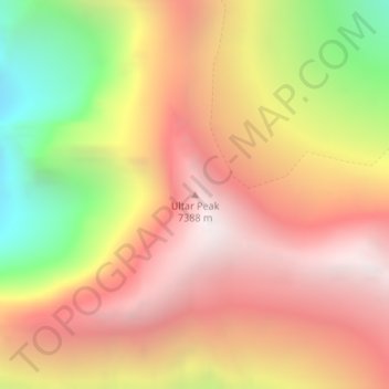
Nombre: Mapa topográfico Ultar Peak, altitud, relieve.
Altitud media: 6.458 m
Altitud mínima: 5.199 m
Altitud máxima: 7.345 m
Otros mapas topográficos
Haga clic en un mapa para ver su topografía, su altitud y su relieve.