
Haz una donación
Mapa topográfico Elaine Castle
Haga clic en el mapa para ver la altitud.
Haz una donación
Acerca de este mapa
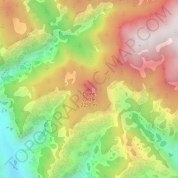
Nombre: Mapa topográfico Elaine Castle, altitud, relieve.
Lugar: Elaine Castle, Coconino County, Arizona, United States (36.30438 -112.28495 36.30448 -112.28485)
Altitud media: 1.869 m
Altitud mínima: 1.268 m
Altitud máxima: 2.448 m
Haz una donación
Otros mapas topográficos
Haga clic en un mapa para ver su topografía, su altitud y su relieve.
Flagstaff
United States > Arizona > Coconino County
Flagstaff, located in Coconino County, Arizona, is characterized by its diverse topography, primarily shaped by its high elevation and volcanic activity. Sitting at around 7,000 feet (approximately 2,130 meters), the city is surrounded by the expansive Coconino National Forest, which features a blend of…
Altitud media: 2.176 m
Upper Saginaw Reservoir
United States > Arizona > Coconino County > Williams City Limits
Altitud media: 2.149 m
Haz una donación
Haz una donación
Cameron
United States > Arizona > Coconino County
Cameron is located on the Navajo Nation. Elevation is 4,216 feet (1,285 m) above sea level. It is immediately south of the Little Colorado River, just above the beginning of the Little Colorado River Gorge and the stream's descent into the Grand Canyon. Cameron lies at the intersection of US 89 and State Route…
Altitud media: 1.331 m
Glen Canyon Dam
United States > Arizona > Coconino County
The Bureau of Reclamation favored the Echo Park site over Glen Canyon, because its narrow canyons and high elevation (more than 5,000 feet (1,500 m), as compared to 3,700 feet (1,100 m) at Glen Canyon) would lead to less evaporation. It said that building Echo Park Dam and a "low" Glen Canyon Dam would save…
Altitud media: 1.171 m
Haz una donación
Supai
United States > Arizona > Coconino County > Supai
Supai can be reached by hiking 8 miles (13 km), descending 2,004 feet (611 m) in elevation from Hualapai Hilltop through the Hualapai Canyon. Alternatively, the AirWest Helicopters service schedules flights from Hualapai Hilltop to Supai. Hualapai Hilltop is located about 70 miles (110 km) from the community…
Altitud media: 1.263 m
Haz una donación
Haz una donación
Valle
United States > Arizona > Coconino County
Valle (Grand Canyon Junction) is a census-designated place in Coconino County, Arizona, United States. As of the 2010 US Census the population of Valle was 832. It lies at an altitude of 5,994 feet (1,827 m), at the junction of U.S. Route 180 and State Route 64. Its attractions include the Valle Airport (40G),…
Altitud media: 1.860 m
Haz una donación
Haz una donación