
Haz una donación
Mapa topográfico Bone Cave
Haga clic en el mapa para ver la altitud.
Haz una donación
Acerca de este mapa
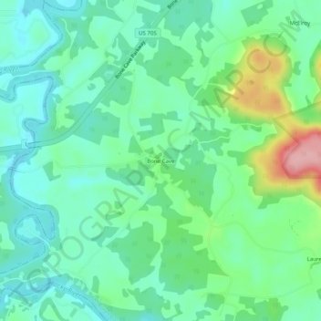
Nombre: Mapa topográfico Bone Cave, altitud, relieve.
Altitud media: 282 m
Altitud mínima: 242 m
Altitud máxima: 391 m
Haz una donación
Otros mapas topográficos
Haga clic en un mapa para ver su topografía, su altitud y su relieve.
Spencer
United States > Tennessee > Van Buren County
Spencer is topographically isolated by the Cumberland Plateau's escarpment to the north and west, the Cane Creek Valley to the east, and the Dry Fork Gulf to the south. Cane Creek, along with its tributary, Dry Fork, slices a narrow valley as it spills down northward toward its confluence with the Caney Fork,…
Altitud media: 496 m