
Haz una donación
Mapa topográfico New York
Haga clic en el mapa para ver la altitud.
Haz una donación
New York
The city's land has been altered substantially by human intervention, with considerable land reclamation along the waterfronts since Dutch colonial times; reclamation is most prominent in Lower Manhattan, with developments such as Battery Park City in the 1970s and 1980s. Some of the natural relief in topography has been evened out, especially in Manhattan.
Haz una donación
Acerca de este mapa
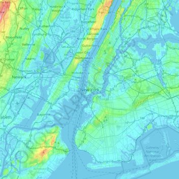
Nombre: Mapa topográfico New York, altitud, relieve.
Lugar: New York, New York County, New York, 10000, United States (40.55273 -74.16602 40.87273 -73.84602)
Altitud media: 15 m
Altitud mínima: -10 m
Altitud máxima: 186 m
Haz una donación
Otros mapas topográficos
Haga clic en un mapa para ver su topografía, su altitud y su relieve.
Highbridge Park
United States > New York > New York County > New York
The north and south wings respectively contain the women's and men's locker rooms and are nearly identical. Both have nine windows separated by eight brick pilasters. The stone capitals of the pilasters line up with the lintels of the windows. Ramps lead from the extreme ends of each wing. The ground slopes…
Altitud media: 30 m
Morningside Park
United States > New York > New York County > New York
Dutch settlers occupied Manhattan in the early 17th century and called the area around Morningside Park Vredendal, meaning 'peaceful dale'. The lowlands to the east were called Flacken by the Dutch, and were later translated to "Flats" in English. The land to the east was not settled initially because of its…
Altitud media: 20 m
Haz una donación
Fort Tryon Park
United States > New York > New York County > New York
In preparation for converting the land into a city park, Rockefeller hired the Olmsted Brothers firm, particularly Frederick Law Olmsted Jr., son of the designer of Central Park. Olmsted's design capitalized on the topography to reveal sweeping vistas of the Hudson River and the Palisades. Olmsted Jr. was…
Altitud media: 20 m
Haz una donación
Haz una donación
Hunter’s Point South Waterfront Park
United States > New York > New York County > New York
Altitud media: 5 m