
Haz una donación
Mapa topográfico Tha Ton
Haga clic en el mapa para ver la altitud.
Haz una donación
Tha Ton
The village is overlooked by a hilltop Buddhist temple known as Wat Tha Ton. The temple complex includes four huge statues of the Buddha, two in typical Thai-style and two showing Chinese influence. One of these, the standing Buddha, is over 10 m tall. Overall, there are nine stations which include statues or shrines. The eighth station houses the monastery and various shrines. The ninth station is a 2 km walk along a paved footpath with elevation gain.
Haz una donación
Acerca de este mapa
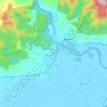
Nombre: Mapa topográfico Tha Ton, altitud, relieve.
Lugar: Tha Ton, Chiang Mai Province, Thailand (20.03772 99.33909 20.07772 99.37909)
Altitud media: 515 m
Altitud mínima: 442 m
Altitud máxima: 878 m
Haz una donación
Otros mapas topográficos
Haga clic en un mapa para ver su topografía, su altitud y su relieve.