
Mapa topográfico Chatsworth
Mapa interactivo
Haga clic en el mapa para ver la altitud.
Acerca de este mapa
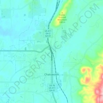
Nombre: Mapa topográfico Chatsworth, altitud, relieve.
Lugar: Chatsworth, Murray County, Georgia, United States (34.74681 -84.82888 34.81781 -84.76255)
Altitud media: 241 m
Altitud mínima: 203 m
Altitud máxima: 460 m
Chatsworth is located in central Murray County at 34°46′20″N 84°46′44″W / 34.77222°N 84.77889°W / 34.77222; -84.77889 (34.772336, -84.778977), in northwestern Georgia. It sits at an elevation of 750 feet (230 m) on the west side of the valley of Holly Creek, with 2,840-foot (870 m) Fort Mountain and 2,780-foot (850 m) Cohutta Mountain rising over the valley to the east.