
Gracias por apoyar a este sitio ❤️
Haz una donación
Haz una donación
Mapa topográfico Hiva Oa
Haga clic en el mapa para ver la altitud.
Gracias por apoyar a este sitio ❤️
Haz una donación
Haz una donación
Acerca de este mapa
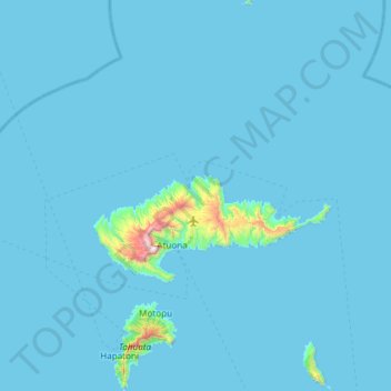
Nombre: Mapa topográfico Hiva Oa, altitud, relieve.
Lugar: Hiva Oa, Marquesas Islands, French Polynesia, France (-10.02399 -139.16389 -9.43299 -138.79678)
Altitud media: 31 m
Altitud mínima: -7 m
Altitud máxima: 1.249 m
Gracias por apoyar a este sitio ❤️
Haz una donación
Haz una donación
Otros mapas topográficos
Haga clic en un mapa para ver su topografía, su altitud y su relieve.
Fatu Huku
France > French Polynesia > Marquesas Islands > Hiva Oa
The island is essentially a huge rock, looming steep-sided out of the ocean and rising to a flattened plateau with a maximum elevation of 361 metres (1,184 ft). Fatu Huku is the youngest of the volcanic Marquesas Islands, estimated to be only 1.3 million years old which accounts, in part, for its ruggedness as…
Altitud media: 8 m
Gracias por apoyar a este sitio ❤️
Haz una donación
Haz una donación