
Gracias por apoyar a este sitio ❤️
Haz una donación
Haz una donación
Mapa topográfico Pocdol Mountains
Haga clic en el mapa para ver la altitud.
Gracias por apoyar a este sitio ❤️
Haz una donación
Haz una donación
Pocdol Mountains
The Pocdol Mountains form part of the boundary between the provinces of Albay and Sorsogon, in Region V, on the island of Luzon, in the Philippines. The group is located south-east of Mayon Volcano, between Albay Gulf and Sorsogon Bay, at 13°3'0"N, 123°57'30"E. The mountains have a triangular footprint of about 225 km2 (87 sq mi). There are several peaks above 1,000 m in elevation. The highest point is reported to be 1,102 m (3,615 ft) above sea level.
Gracias por apoyar a este sitio ❤️
Haz una donación
Haz una donación
Acerca de este mapa
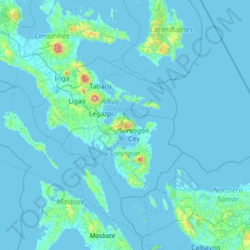
Nombre: Mapa topográfico Pocdol Mountains, altitud, relieve.
Altitud media: 46 m
Altitud mínima: -2 m
Altitud máxima: 2.259 m
Gracias por apoyar a este sitio ❤️
Haz una donación
Haz una donación
Otros mapas topográficos
Haga clic en un mapa para ver su topografía, su altitud y su relieve.