
Gracias por apoyar a este sitio ❤️
Haz una donación
Haz una donación
Mapa topográfico Katun Popadija
Haga clic en el mapa para ver la altitud.
Gracias por apoyar a este sitio ❤️
Haz una donación
Haz una donación
Acerca de este mapa
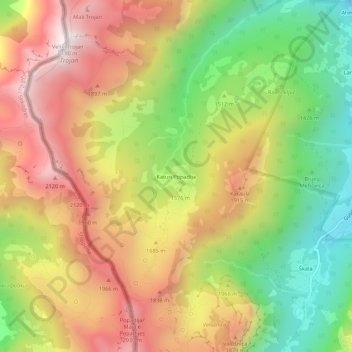
Nombre: Mapa topográfico Katun Popadija, altitud, relieve.
Lugar: Katun Popadija, Gusinje Municipality, Montenegro (42.51579 19.74660 42.55579 19.78660)
Altitud media: 1.598 m
Altitud mínima: 1.038 m
Altitud máxima: 2.156 m
Gracias por apoyar a este sitio ❤️
Haz una donación
Haz una donación
Otros mapas topográficos
Haga clic en un mapa para ver su topografía, su altitud y su relieve.
Accursed Mountains
Montenegro > Gusinje Municipality
The Accursed Mountains are a typical Dinaric karst high mountain range with a pronounced steep topography and glacial features. Maximum relief differences of 1,800 metres (5,900 ft) are found in the Valbona, Grbaja and Ropojani and Cem valleys. Overhanging walls and ridges forming pointed peaks are typical of…
Altitud media: 1.676 m