
Gracias por apoyar a este sitio ❤️
Haz una donación
Haz una donación
Mapa topográfico Novačka
Haga clic en el mapa para ver la altitud.
Gracias por apoyar a este sitio ❤️
Haz una donación
Haz una donación
Acerca de este mapa
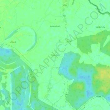
Nombre: Mapa topográfico Novačka, altitud, relieve.
Altitud media: 120 m
Altitud mínima: 112 m
Altitud máxima: 129 m
Gracias por apoyar a este sitio ❤️
Haz una donación
Haz una donación
Otros mapas topográficos
Haga clic en un mapa para ver su topografía, su altitud y su relieve.
Grad Križevci
Croatia > Koprivnica-Križevci County
Topographically, it lies on Pleistocene foundations, between swamped alluvial valleys of the brook Vrtlin from the east and the brook Koruska from the west. Relief, geological-petrografical structure, convenient climate and abundance of water, all contribute to the economic and demographic development of the…
Altitud media: 196 m
Gracias por apoyar a este sitio ❤️
Haz una donación
Haz una donación