
Mapa topográfico Utah
Mapa interactivo
Haga clic en el mapa para ver la altitud.
Acerca de este mapa
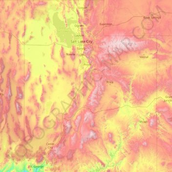
Nombre: Mapa topográfico Utah, altitud, relieve.
Lugar: Utah, United States (36.99781 -114.05285 42.00170 -109.04158)
Altitud media: 1.876 m
Altitud mínima: 789 m
Altitud máxima: 3.986 m
Western Utah is mostly arid desert with a basin and range topography. Small mountain ranges and rugged terrain punctuate the landscape. The Bonneville Salt Flats are an exception, being comparatively flat as a result of once forming the bed of ancient Lake Bonneville. Great Salt Lake, Utah Lake, Sevier Lake, and Rush Lake are all remnants of this ancient freshwater lake, which once covered most of the eastern Great Basin. West of the Great Salt Lake, stretching to the Nevada border, lies the arid Great Salt Lake Desert. One exception to this aridity is Snake Valley, which is (relatively) lush due to large springs and wetlands fed from groundwater derived from snow melt in the Snake Range, Deep Creek Range, and other tall mountains to the west of Snake Valley. Great Basin National Park is just over the Nevada state line in the southern Snake Range. One of western Utah's most impressive, but least visited attractions is Notch Peak, the tallest limestone cliff in North America, located west of Delta.
Otros mapas topográficos
Haga clic en un mapa para ver su topografía, su altitud y su relieve.
Houston
United States > Texas > Harris County
Houston, Harris County, Texas, United States
Altitud media: 25 m
Jacksonville
United States > Florida > Duval County
Jacksonville, Duval County, Florida, United States
Altitud media: 10 m
Spokane
United States > Washington > Spokane County
Spokane, Spokane County, Washington, United States
Altitud media: 655 m
Littleton
United States > Colorado > Arapahoe County
Littleton, Arapahoe County, Colorado, United States
Altitud media: 1.684 m
Lancaster County
Lancaster County, Pennsylvania, United States
Altitud media: 158 m
Albuquerque
United States > New Mexico > Bernalillo County
Albuquerque, Bernalillo County, New Mexico, United States
Altitud media: 1.688 m
Provo
United States > Utah > Utah County
Provo, Utah County, Utah, United States
Altitud media: 1.728 m
Laurel
United States > Ohio > Clermont County
Laurel, Monroe Township, Clermont County, Ohio, 45153, United States
Altitud media: 252 m
Hudson River
Hudson River, New Jersey, 12834:12871, United States
Altitud media: 297 m
Manhattan
United States > New York > New York County > New York
Manhattan, New York County, New York, United States
Altitud media: 16 m
San Mateo County
San Mateo County, California, United States
Altitud media: 109 m
New Orleans
United States > Louisiana > Orleans Parish
New Orleans, Orleans Parish, Louisiana, United States
Altitud media: 1 m
Highlands Ranch
United States > Colorado > Douglas County
Highlands Ranch, Douglas County, Colorado, 80126, United States
Altitud media: 1.758 m
Atlantic City
United States > New Jersey > Atlantic County
Atlantic City, Atlantic County, New Jersey, 08401, United States
Altitud media: 1 m
Coeur d'Alene
United States > Idaho > Kootenai County
Coeur d'Alene, Kootenai County, Idaho, United States
Altitud media: 719 m
Lehigh County
Lehigh County, Pennsylvania, United States
Altitud media: 186 m
Lakewood
United States > Colorado > Jefferson County > Lakewood
Lakewood, Jefferson County, Colorado, United States
Altitud media: 1.717 m
Cumming
United States > Georgia > Forsyth County
Cumming, Forsyth County, Georgia, United States
Altitud media: 365 m
Morgantown
United States > West Virginia > Monongalia County
Morgantown, Monongalia County, West Virginia, United States
Altitud media: 337 m
Des Moines
United States > Iowa > Polk County
Des Moines, Polk County, Iowa, United States
Altitud media: 264 m