
Haz una donación
Mapa topográfico Donji Lapac
Haga clic en el mapa para ver la altitud.
Haz una donación
Acerca de este mapa
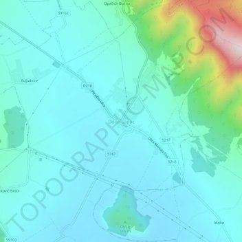
Nombre: Mapa topográfico Donji Lapac, altitud, relieve.
Altitud media: 637 m
Altitud mínima: 545 m
Altitud máxima: 1.106 m
Haz una donación
Otros mapas topográficos
Haga clic en un mapa para ver su topografía, su altitud y su relieve.
Perušić
The Municipality of Perušić is located in the southeastern part of Lika, at an altitude of 575–600 metres (1,886–1,969 ft), in a valley of the Lika River watershed. It lies in a field, Perušićko polje, bounded by the hills west of Klis and the railway line east of the Old Town of Perušić (Stari grad…
Altitud media: 608 m
Plitvice Lakes National Park
The 16 lakes are separated into an upper and lower cluster formed by runoff from the mountains, descending from an altitude of 636 to 503 m (2,087 to 1,650 ft) over a distance of some 8 kilometres (5.0 mi), aligned in a south–north direction. The lakes collectively cover an area of about 0.77 square miles,…
Altitud media: 765 m
Haz una donación
Otočac
Otočac is located in the western part of Gacko Polje, the karst field of centrally located Gacka river, located between Velebit and Mala Kapela, at an elevation of 459m. The town lies to the southeast of Senj, northwest of Gospić and west of Plitvice.
Altitud media: 511 m
Plitvice Lakes National Park
The afforested mountain slopes serve as water reservoirs. They are also a refuge for many animal species. The large difference in altitude in a narrow space between the mountains in the south and the Korana river in the north also represents a significant criterion for biodiversity in this region. The overall…
Altitud media: 765 m
Haz una donación
Plitvice Lakes National Park
The area of Plitvice Lakes National Park extends across two political subdivisions or counties (Croatian županija). Its 296.85 km2 (114.61 sq mi) area is divided between Lika-Senj County (90.7 percent) and Karlovac County (9.3 percent), hence the national park authority is under national jurisdiction. The…
Altitud media: 765 m
Haz una donación
Haz una donación
Haz una donación
Haz una donación
Haz una donación
Haz una donación