
Mapa topográfico Tyree
Mapa interactivo
Haga clic en el mapa para ver la altitud.
Acerca de este mapa
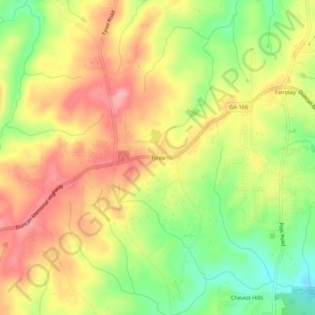
Nombre: Mapa topográfico Tyree, altitud, relieve.
Lugar: Tyree, Douglas County, Georgia, United States (33.59511 -84.89938 33.63511 -84.85938)
Altitud media: 346 m
Altitud mínima: 284 m
Altitud máxima: 397 m
Otros mapas topográficos
Haga clic en un mapa para ver su topografía, su altitud y su relieve.
Chapel Hill
United States > Georgia > Douglas County
Chapel Hill, Douglas County, Georgia, 30135, United States
Altitud media: 296 m
Winston
United States > Georgia > Douglas County
Winston, Douglas County, Georgia, 30187, United States
Altitud media: 340 m
Douglasville
United States > Georgia > Douglas County
Douglasville, Douglas County, Georgia, 30133, United States
Altitud media: 310 m
Andy Mountain
United States > Georgia > Douglas County
Andy Mountain, Douglas County, Georgia, 30187, United States
Altitud media: 344 m
Sweetwater Creek State Park
United States > Georgia > Douglas County
Sweetwater Creek State Park, Douglas County, Georgia, 30122, United States
Altitud media: 288 m
Lithia Springs
United States > Georgia > Douglas County
Lithia Springs, Douglas County, Georgia, 30122, United States
Altitud media: 295 m
Douglas Estates
United States > Georgia > Douglas County > Douglas Estates
Douglas Estates, Douglas County, Georgia, 30135, United States
Altitud media: 292 m