
Gracias por apoyar a este sitio ❤️
Haz una donación
Haz una donación
Mapa topográfico Baan Tai
Haga clic en el mapa para ver la altitud.
Gracias por apoyar a este sitio ❤️
Haz una donación
Haz una donación
Acerca de este mapa
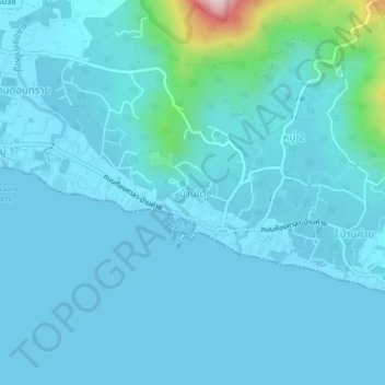
Nombre: Mapa topográfico Baan Tai, altitud, relieve.
Altitud media: 34 m
Altitud mínima: -1 m
Altitud máxima: 382 m
Gracias por apoyar a este sitio ❤️
Haz una donación
Haz una donación
Otros mapas topográficos
Haga clic en un mapa para ver su topografía, su altitud y su relieve.
Ko Pha Ngan
Due to its topography, the population hugs the coastline. The mountainous interior is generally inaccessible. More than half the island designated as national park and Ko Pha-ngan has more than 80 km2 (31 sq mi) of relatively unspoiled rain forest with diverse flora and fauna. It is also considered a spiritual…
Altitud media: 84 m
Gracias por apoyar a este sitio ❤️
Haz una donación
Haz una donación