
Haz una donación
Mapa topográfico Mooresburg
Haga clic en el mapa para ver la altitud.
Haz una donación
Acerca de este mapa
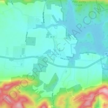
Nombre: Mapa topográfico Mooresburg, altitud, relieve.
Altitud media: 372 m
Altitud mínima: 316 m
Altitud máxima: 549 m
Haz una donación
Otros mapas topográficos
Haga clic en un mapa para ver su topografía, su altitud y su relieve.
Rogersville
United States > Tennessee > Hawkins County
Rogersville is located slightly southwest of the center of Hawkins County. According to the United States Census Bureau, the town has a total area of 3.4 square miles (8.8 km2), all land. The town is in the valley of Crockett Creek, a southwest-flowing tributary of the Holston River. The elevation of…
Altitud media: 416 m
Haz una donación
Rogersville
United States > Tennessee > Hawkins County
Rogersville is located slightly southwest of the center of Hawkins County. According to the United States Census Bureau, the town has a total area of 3.4 square miles (8.8 km2), all land. The town is in the valley of Crockett Creek, a southwest-flowing tributary of the Holston River. The elevation of…
Altitud media: 416 m