
Gracias por apoyar a este sitio ❤️
Haz una donación
Haz una donación
Mapa topográfico Thrippunithura
Haga clic en el mapa para ver la altitud.
Gracias por apoyar a este sitio ❤️
Haz una donación
Haz una donación
Thrippunithura
In the south, Thrippunithura borders the Vembanad, the longest lake in India. The lake provides facilities for inland water navigation, with the Champakkara canal stretch of the National Waterway 3 forming its western boundary with Kochi and Maradu. The canal then merges with the Chithrapuzha river in the north, near Irumpanam. Thrippunithura has an average elevation of 8 m (26 ft) above sea level, with the areas near Thiruvankulam in the easternmost boundaries rising to 30m.
Gracias por apoyar a este sitio ❤️
Haz una donación
Haz una donación
Acerca de este mapa
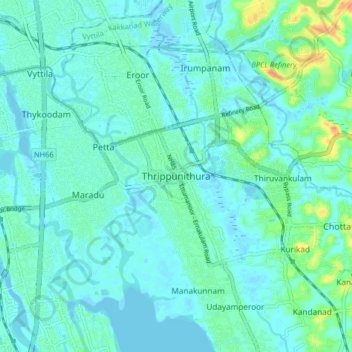
Nombre: Mapa topográfico Thrippunithura, altitud, relieve.
Altitud media: 8 m
Altitud mínima: -5 m
Altitud máxima: 42 m
Gracias por apoyar a este sitio ❤️
Haz una donación
Haz una donación
Otros mapas topográficos
Haga clic en un mapa para ver su topografía, su altitud y su relieve.