
Gracias por apoyar a este sitio ❤️
Haz una donación
Haz una donación
Mapa topográfico Aska
Haga clic en el mapa para ver la altitud.
Gracias por apoyar a este sitio ❤️
Haz una donación
Haz una donación
Acerca de este mapa
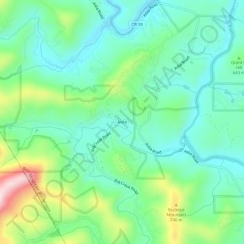
Nombre: Mapa topográfico Aska, altitud, relieve.
Lugar: Aska, Fannin County, Georgia, United States (34.74786 -84.28214 34.78786 -84.24214)
Altitud media: 629 m
Altitud mínima: 534 m
Altitud máxima: 873 m
Gracias por apoyar a este sitio ❤️
Haz una donación
Haz una donación
Otros mapas topográficos
Haga clic en un mapa para ver su topografía, su altitud y su relieve.
Lake Blue Ridge
United States > Georgia > Fannin County > Morganton
As part of the Blue Ridge Dam Rehabilitation project, the Tennessee Valley Authority, began slowly lowering the elevation of Blue Ridge Lake in July 2010. This rehabilitation project aimed to repair the dam penstock and to stabilize both the upstream and downstream faces of the dam. The project reduced the…
Altitud media: 572 m