
Haz una donación
Mapa topográfico Pavia
Haga clic en el mapa para ver la altitud.
Haz una donación
Pavia
From an elevation point of view, the city has various heights. The highest point is located in the area of the Visconti Castle, about 80 m (260 ft) above sea level, and then slowly declines. From an altitude of 80 m (260 ft), you pass to 77 m (253 ft) in about 500 m (550 yd; 1,600 ft). Downstream from Piazza Vittoria, where the cardo and decumanus of the Roman city crossed, the slope becomes more pronounced, up to just under 60 m (200 ft) above sea level near the Ponte Coperto.
Haz una donación
Acerca de este mapa
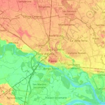
Nombre: Mapa topográfico Pavia, altitud, relieve.
Lugar: Pavia, Lombardy, 27100, Italy (45.15574 9.09038 45.23331 9.24055)
Altitud media: 74 m
Altitud mínima: 50 m
Altitud máxima: 93 m
Haz una donación
Otros mapas topográficos
Haga clic en un mapa para ver su topografía, su altitud y su relieve.
Haz una donación
Haz una donación
Haz una donación
Haz una donación