
Haz una donación
Mapa topográfico Tando Jam
Haga clic en el mapa para ver la altitud.
Haz una donación
Tando Jam
Tamdo Jam is situated on the east of Indus River. The Hyderabad-Murpurkhas Road passes through the town. Its average elevation is 22 metres above sea level.
Haz una donación
Acerca de este mapa
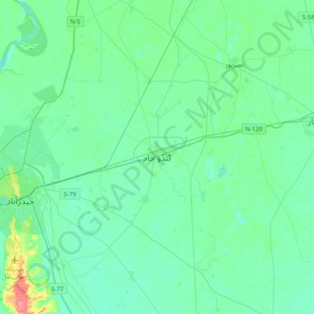
Nombre: Mapa topográfico Tando Jam, altitud, relieve.
Lugar: Tando Jam, Sindh, Pakistan (25.26453 68.36962 25.58453 68.68962)
Altitud media: 22 m
Altitud mínima: 12 m
Altitud máxima: 69 m
Haz una donación
Otros mapas topográficos
Haga clic en un mapa para ver su topografía, su altitud y su relieve.
Karachi Division
Karachi lies very close to a major fault line, where the Indian tectonic plate meets the Arabian tectonic plate. However, Karachi lies near the western edge of the Indian Plate, on the Indo Gangetic Plain. Within the city of Karachi are two small ranges: the Khasa Hills and Mulri Hills, which lie in the…
Altitud media: 89 m
Haz una donación
Karachi Division
Karachi lies very close to a major fault line, where the Indian tectonic plate meets the Arabian tectonic plate. Within the city of Karachi are two small ranges: the Khasa Hills and Mulri Hills, which lie in the northwest and act as a barrier between North Nazimabad and Orangi. Karachi's hills are barren and…
Altitud media: 89 m
Haz una donación
Haz una donación
Karachi Division
Karachi lies very close to a major fault line, where the Indian tectonic plate meets the Arabian tectonic plate. However, Karachi lies near the western edge of the Indian Plate, on the Indo Gangetic Plain. Within the city of Karachi are two small ranges: the Khasa Hills and Mulri Hills, which lie in the…
Altitud media: 89 m
Haz una donación
Haz una donación
Haz una donación
Haz una donación
Haz una donación
Haz una donación
Haz una donación
Karachi Division
Karachi lies very close to a major fault line, where the Indian tectonic plate meets the Arabian tectonic plate. Within the city of Karachi are two small ranges: the Khasa Hills and Mulri Hills, which lie in the northwest and act as a barrier between North Nazimabad and Orangi. Karachi's hills are barren and…
Altitud media: 89 m
Haz una donación
Haz una donación
Haz una donación