
Mapa topográfico Λιάκουρα
Mapa interactivo
Haga clic en el mapa para ver la altitud.
Acerca de este mapa
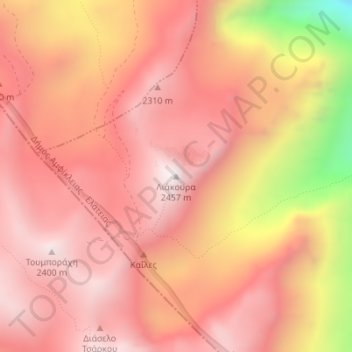
Nombre: Mapa topográfico Λιάκουρα, altitud, relieve.
Altitud media: 2.127 m
Altitud mínima: 1.388 m
Altitud máxima: 2.433 m
Otros mapas topográficos
Haga clic en un mapa para ver su topografía, su altitud y su relieve.
Σπαρτιά
Greece > Thessaly - Central Greece > Σπαρτιά
Σπαρτιά, Δήμος Στυλίδας, Regional Unit of Phthiotis, Region of Central Greece, Thessaly - Central Greece, 35013, Greece
Altitud media: 335 m
Zagora
Greece > Thessaly - Central Greece > Zagora
Zagora, Zagora - Mouresi Municipality, Regional Unit of Magnesia, Region of Thessaly, Thessaly - Central Greece, 37001, Greece
Altitud media: 523 m
Lampinou
Greece > Thessaly - Central Greece > Lampinou
Lampinou, South Pilio Municipality, Regional Unit of Magnesia, Region of Thessaly, Thessaly - Central Greece, 37012, Greece
Altitud media: 274 m
Σταυρός
Greece > Thessaly - Central Greece
Σταυρός, Alonnisos Municipality, Regional Unit of Sporades, Region of Thessaly, Thessaly - Central Greece, Greece
Altitud media: 24 m
Volos
Greece > Thessaly - Central Greece > Volos
Volos, Volos Municipality, Regional Unit of Magnesia, Region of Thessaly, Thessaly - Central Greece, 38333, Greece
Altitud media: 249 m
Krannonas
Greece > Thessaly - Central Greece > Krannonas
Krannonas, Kileler Municipality, Regional Unit of Larisa, Region of Thessaly, Thessaly - Central Greece, 41500, Greece
Altitud media: 115 m
Pindus
Greece > Thessaly - Central Greece
Pindus, Δήμος Αργιθέας, Karditsa Regional Unit, Region of Thessaly, Thessaly - Central Greece, Greece
Altitud media: 1.510 m
Dytiki Frangista
Greece > Thessaly - Central Greece > Dytiki Frangista
Dytiki Frangista, Δήμος Αγράφων, Regional Unit of Evrytania, Region of Central Greece, Thessaly - Central Greece, 36071, Greece
Altitud media: 760 m