
Gracias por apoyar a este sitio ❤️
Haz una donación
Haz una donación
Mapa topográfico Dion - Olympos Municipality
Haga clic en el mapa para ver la altitud.
Gracias por apoyar a este sitio ❤️
Haz una donación
Haz una donación
Acerca de este mapa
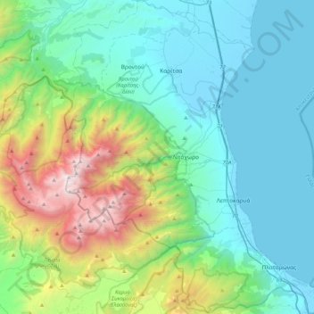
Nombre: Mapa topográfico Dion - Olympos Municipality, altitud, relieve.
Altitud media: 629 m
Altitud mínima: -2 m
Altitud máxima: 2.889 m
Gracias por apoyar a este sitio ❤️
Haz una donación
Haz una donación
Otros mapas topográficos
Haga clic en un mapa para ver su topografía, su altitud y su relieve.
Λιτόχωρο
Greece > Central Macedonia > Pieria Regional Unit
At an altitude of 850 m, beside the Enipeas gorge, Saint Dionysios built a monastery. Founded 1542, its name was Agia Triada, what means Holy Trinity, later changed to the name of the Saint. Plundered and burned several times in its history, it received the final blow from German troops in April 1943.
Altitud media: 396 m
Gracias por apoyar a este sitio ❤️
Haz una donación
Haz una donación