
Gracias por apoyar a este sitio ❤️
Haz una donación
Haz una donación
Mapa topográfico Samarina
Haga clic en el mapa para ver la altitud.
Gracias por apoyar a este sitio ❤️
Haz una donación
Haz una donación
Samarina
Samarina is located on an eastern spur of Mount Smolikas, the highest of the Pindus range and the second-highest mountain in all of Greece. At an altitude of 1380–1515 meters (4528' to 4970'), it is considered one of the highest villages in Greece and also one of the highest in the Balkans; its height puts it among soaring settlements such as: Aetomilitsa (Densko) and Seli (Selia).
Gracias por apoyar a este sitio ❤️
Haz una donación
Haz una donación
Acerca de este mapa
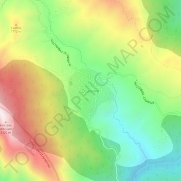
Nombre: Mapa topográfico Samarina, altitud, relieve.
Altitud media: 1.558 m
Altitud mínima: 1.158 m
Altitud máxima: 2.092 m
Gracias por apoyar a este sitio ❤️
Haz una donación
Haz una donación
Otros mapas topográficos
Haga clic en un mapa para ver su topografía, su altitud y su relieve.
Municipality of Grevena
Greece > Epirus and Western Macedonia > Grevena Regional Unit
Altitud media: 878 m