
Haz una donación
Mapa topográfico Gioia del Colle
Haga clic en el mapa para ver la altitud.
Haz una donación
Gioia del Colle
Gioia del Colle is on the top of a hill at 360 m a.s.l. It is located in the southern part of the Murge, in the "Sella di Gioia del Colle". It is between the North-West Murge and the South-West Murge and the Adriatic Sea and the Ionian Sea. The municipal area has an area of 206.48 km2 and it reaches a maximum altitude of 435 m a.s.l. and a minimum of 296 m a.s.l. Its area borders to the North-West with Acquaviva delle Fonti, to the North with Sammichele di Bari, to the North-East with Turi, to the East with Putignano and Noci, to the South-East with Mottola, to the South with Castellaneta, to the South-West with Laterza and to the West with Santeramo in Colle.
Haz una donación
Acerca de este mapa
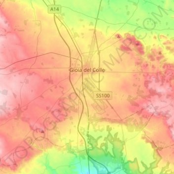
Nombre: Mapa topográfico Gioia del Colle, altitud, relieve.
Lugar: Gioia del Colle, Bari, Apulia, 70023, Italy (40.69298 16.78760 40.86271 17.03540)
Altitud media: 351 m
Altitud mínima: 242 m
Altitud máxima: 440 m
Haz una donación
Otros mapas topográficos
Haga clic en un mapa para ver su topografía, su altitud y su relieve.