
Haz una donación
Mapa topográfico Little Barren
Haga clic en el mapa para ver la altitud.
Haz una donación
Acerca de este mapa
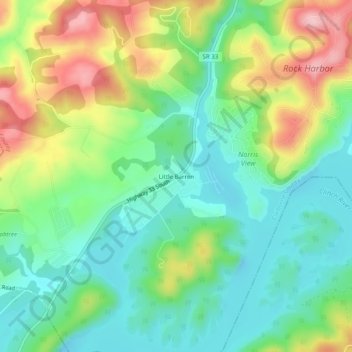
Nombre: Mapa topográfico Little Barren, altitud, relieve.
Altitud media: 364 m
Altitud mínima: 295 m
Altitud máxima: 491 m
Haz una donación
Otros mapas topográficos
Haga clic en un mapa para ver su topografía, su altitud y su relieve.
New Tazewell
United States > Tennessee > Claiborne County
When the railroad line was built from Knoxville through Cumberland Gap in the late 1880s, it bypassed the city of Tazewell. It is uncertain whether the railroad was unable to obtain right of way, or whether the decision was made because of topography, but the railroad depot was built about two miles to the…
Altitud media: 465 m
Haz una donación
New Tazewell
United States > Tennessee > Claiborne County
When the railroad line was built from Knoxville through Cumberland Gap in the late 1880s, it bypassed the city of Tazewell. It is uncertain whether the railroad was unable to obtain right of way, or whether the decision was made because of topography, but the railroad depot was built about two miles to the…
Altitud media: 465 m