
Mapa topográfico Ogre
Haga clic en el mapa para ver la altitud.
Ogre
Baintha Brakk is exceptional in its combination of altitude, height above local terrain, and steepness. It is a complex granite tower, steeper and rockier than most other Karakoram peaks. (The Latok peaks next to Baintha Brakk are similar, however.) For example, its South Face rises over 3,000 m (9,800 ft) above the Uzun Brakk Glacier in only 2 km (1.2 mi) of horizontal distance.
Acerca de este mapa
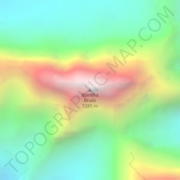
Nombre: Mapa topográfico Ogre, altitud, relieve.
Altitud media: 5.853 m
Altitud mínima: 5.106 m
Altitud máxima: 7.174 m
Otros mapas topográficos
Haga clic en un mapa para ver su topografía, su altitud y su relieve.
Biafo Glacier
Pakistan > Gilgit-Baltistan > Shigar District
Biafo Glacier converging at Hispar La with 49 kilometres (30 mi) long Hispar Glacier situated at an elevation of 5,128 metres (16,824 ft), forms the glacial system considered as the world's longest non-polar glacial system which spans an overall distance of around 120 kilometres (75 mi). This frozen pathway…
Altitud media: 4.618 m