
Haz una donación
Mapa topográfico Haikou City
Haga clic en el mapa para ver la altitud.
Haz una donación
Acerca de este mapa
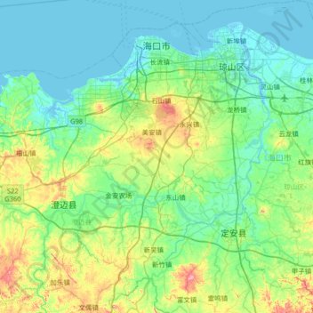
Nombre: Mapa topográfico Haikou City, altitud, relieve.
Lugar: Haikou City, Hainan Province, China (19.52594 110.10308 20.13217 110.70807)
Altitud media: 40 m
Altitud mínima: -3 m
Altitud máxima: 203 m
Haz una donación
Otros mapas topográficos
Haga clic en un mapa para ver su topografía, su altitud y su relieve.
Mischief Reef
China > Hainan Province > Sansha
Mischief Reef, also known as Panganiban Reef (Tagalog: Bahura ng Panganiban; Vietnamese: Đá Vành Khăn; Mandarin Chinese: 美濟礁/美济礁; pinyin: Měijì Jiāo; lit. 'Meiji Reef'), is a low tide elevation (LTE) reef/atoll surrounding a large lagoon in the SE of Dangerous Ground in the east of the…
Altitud media: 0 m
Subi Reef
China > Hainan Province > Nansha District
On 12 July 2016, the UNCLOS special arbitral tribunal in the Philippines v. China case confirmed that Subi Reef is, or in its natural condition was, exposed at low tide and submerged at high tide and is, accordingly a low-tide elevation that does not generate entitlement to a territorial sea, exclusive…
Altitud media: 0 m
Scarborough Shoal
China > Hainan Province > Sansha
The Philippines state that its assertion of sovereignty over the atoll is based on the juridical criteria established by public international law on the lawful methods for the acquisition of sovereignty. Among the criteria (effective occupation, cession, prescription, conquest, and accretion), the Philippine…
Altitud media: 0 m
Haz una donación