
Haz una donación
Mapa topográfico Yunhe
Haga clic en el mapa para ver la altitud.
Haz una donación
Acerca de este mapa
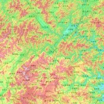
Nombre: Mapa topográfico Yunhe, altitud, relieve.
Lugar: Yunhe, Zhejiang, China (27.40961 118.87794 28.80961 120.27794)
Altitud media: 600 m
Altitud mínima: 3 m
Altitud máxima: 1.867 m
Haz una donación
Otros mapas topográficos
Haga clic en un mapa para ver su topografía, su altitud y su relieve.
Haz una donación
Wenzhou
Most of Wenzhou's landscape is mountainous, with many mountain tops reaching altitudes in excess of 1,000 m (3,300 ft), for example in the Yandang Mountains, a coastal mountain range dominating the eastern part of prefecture. Another dominating landscape element is the Ou River, the largest river in Wenzhou…
Altitud media: 222 m
Haz una donación
Haz una donación
Haz una donación
Wenzhou
Most of Wenzhou's landscape is mountainous, with many mountain tops reaching altitudes in excess of 1,000 m (3,300 ft), for example in the Yandang Mountains, a coastal mountain range dominating the eastern part of prefecture. Another dominating landscape element is the Ou River, the largest river in Wenzhou…
Altitud media: 217 m
Haz una donación
Haz una donación
Haz una donación
Haz una donación
Wenzhou
Most of Wenzhou's landscape is mountainous, with many mountain tops reaching altitudes in excess of 1,000 m (3,300 ft), for example in the Yandang Mountains, a coastal mountain range dominating the eastern part of prefecture. Another dominating landscape element is the Ou River, the largest river in Wenzhou…
Altitud media: 222 m
Haz una donación
Shangyu District
Fuzhi mountain located in the border area of Shangyu, Shengzhou and Yuyao city. The elevation of Fuzhi mountain is 861.3 meters, cloud and mist around the mountain almost whole year, and a stone river rolling with the slope. The existence of stone river duo to the quaternary glacier movements.
Altitud media: 89 m
Haz una donación
Anji County
Anji County is located within the Yangtze Delta, where the Yangtze meets the East China Sea. The Tianmu Mountains run through southwest portion of the county, with the county's highest point, Longwang Mountain [zh], reaching 1,587.4 metres (5,208 ft) in elevation. Xitiao River, the county's longest river,…
Altitud media: 207 m
Haz una donación
Haz una donación
Haz una donación
Wenzhou
Most of Wenzhou's landscape is mountainous, with many mountain tops reaching altitudes in excess of 1,000 m (3,300 ft), for example in the Yandang Mountains, a coastal mountain range dominating the eastern part of prefecture. Another dominating landscape element is the Ou River, the largest river in Wenzhou…
Altitud media: 222 m
Haz una donación
Lishui
Lishui is situated in the southwest of Zhejiang province, with its administrative area covering latitude 27° 25' to 28° 57' N and longitude 118° 41' to 120° 26' E. It borders the cities of Ningde and Nanping (Fujian province) to the southwest as well as Quzhou to the northwest, Jinhua to the north, Taizhou…
Altitud media: 498 m
Haz una donación
Haz una donación
Haz una donación
Haz una donación
Haz una donación
Dongyang
Dongbai Mountain (东白山)'s highest peak, Taibai Peak) is the main peak of the Kuaiji Mountains, with an altitude of 1194.6 meters. The main peak is located in Hulu Town, Dongyang City, Zhejiang Province. Since ancient times, it has been the head of the famous mountains in central Zhejiang, the "roof" of…
Altitud media: 262 m
Haz una donación
Haz una donación
Haz una donación
Xihu District
About the formation of West Lake, there are few records in ancient documents. The "West Lake Sight-Seeing Record" (西湖游覽志) says, "West Lake is surrounded by mountains on three sides. Streams wander down the hills into the pond. There're hundreds of springs underneath. Accumulated water forms the…
Altitud media: 19 m
Haz una donación
Fuyang
Located in northwestern Zhejiang province, in 1994 Fuyang was administratively merged into Hangzhou. The city has several highways including the G320 national road, Hangxijing, as well as highways 05, 23, 19 and 14. Fuyang is 51 kilometres (32 mi) from Hangzhou and convenient transport makes it possible to…
Altitud media: 154 m
Haz una donación
Dongyang
Dongbai Mountain (东白山)'s highest peak, Taibai Peak) is the main peak of the Kuaiji Mountains, with an altitude of 1194.6 meters. The main peak is located in Hulu Town, Dongyang City, Zhejiang Province. Since ancient times, it has been the head of the famous mountains in central Zhejiang, the "roof" of…
Altitud media: 262 m
Haz una donación