
Haz una donación
Mapa topográfico Marcinek
Haga clic en el mapa para ver la altitud.
Haz una donación
Acerca de este mapa
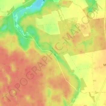
Nombre: Mapa topográfico Marcinek, altitud, relieve.
Altitud media: 90 m
Altitud mínima: 58 m
Altitud máxima: 107 m
Haz una donación
Otros mapas topográficos
Haga clic en un mapa para ver su topografía, su altitud y su relieve.
Chodzież
Poland > Greater Poland Voivodeship > Chodzież County
Five kilometers west of Chodzież, at the edge of the Chodzieskie lakelands, Mt. Gontyniec rises 192 meters above sea level as the highest peak in a chain of moraine hills; at the same time it has the highest elevation in northern Poland. Deep valleys and ridges covered with a 100-year-old beech forest ensure…
Altitud media: 79 m
Chodzież
Poland > Greater Poland Voivodeship > Chodzież County > Chodzież
Five kilometers west of Chodzież, at the edge of the Chodzieskie lakelands, Mt. Gontyniec rises 192 meters above sea level as the highest peak in a chain of moraine hills; at the same time it has the highest elevation in northern Poland. Deep valleys and ridges covered with a 100-year-old beech forest ensure…
Altitud media: 78 m