
Mapa topográfico Ausangate
Mapa interactivo
Haga clic en el mapa para ver la altitud.
Acerca de este mapa
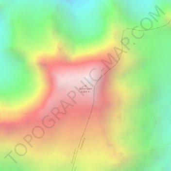
Nombre: Mapa topográfico Ausangate, altitud, relieve.
Altitud media: 5.617 m
Altitud mínima: 4.874 m
Altitud máxima: 6.359 m
Ausangate or Auzangate (in Hispanicized spellings) is a mountain of the Vilcanota mountain range in the Andes of Peru. With an elevation of 6,384 metres, it is situated around 100 kilometres southeast of Cusco in the Cusco Region, Canchis Province, Pitumarca District, and in the Quispicanchi Province, Ocongate District.