
Haz una donación
Mapa topográfico Chongqing
Haga clic en el mapa para ver la altitud.
Haz una donación
Chongqing
The central urban area of Chongqing, or Chongqing proper, is a city of unique features. Built on mountains and partially surrounded by the Yangtze and Jialing rivers, it is known as a "mountain city" and a "city on rivers". The night scene of the city is very illuminated, with millions of lights and their reflection on the rivers. With its special topographical features, Chongqing has the unique scenery of mountains, rivers, forests, springs, waterfalls, gorges, and caves. Li Bai, a famous poet of the Tang dynasty, was inspired by the natural scenery and wrote this epigram.
Haz una donación
Acerca de este mapa
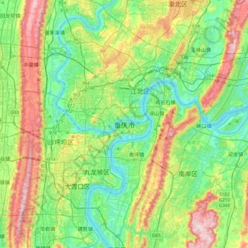
Nombre: Mapa topográfico Chongqing, altitud, relieve.
Lugar: Chongqing, Yuzhong District, Chongqing, 400014, China (29.40567 106.38792 29.72567 106.70792)
Altitud media: 318 m
Altitud mínima: 148 m
Altitud máxima: 681 m
Haz una donación
Otros mapas topográficos
Haga clic en un mapa para ver su topografía, su altitud y su relieve.
Jiangjin District
Jiangjin lies within central China at 105°49′—106°38′of longitude and 28°28′—29°28′of north latitude. The landscape and topography of Jiangjin slopes from high elevations in the south and low in the north. Luohuangzhongba stands at the lowest elevation (178.5 m). The highest site, Wugongba in…
Altitud media: 521 m
Haz una donación