
Haz una donación
Mapa topográfico Charleston County
Haga clic en el mapa para ver la altitud.
Haz una donación
Acerca de este mapa
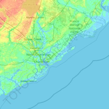
Nombre: Mapa topográfico Charleston County, altitud, relieve.
Lugar: Charleston County, South Carolina, United States (32.49272 -80.45355 33.21502 -79.25611)
Altitud media: 5 m
Altitud mínima: -4 m
Altitud máxima: 40 m
Haz una donación
Otros mapas topográficos
Haga clic en un mapa para ver su topografía, su altitud y su relieve.
Haz una donación
Haz una donación
Forest Park
United States > South Carolina > Charleston County > Charleston > Maryville
Altitud media: 5 m
Haz una donación
Florence Soccer Complex
United States > South Carolina > Florence County > Florence
Altitud media: 42 m
Haz una donación
Haz una donación
Haz una donación
Haz una donación
North Charleston Wannamaker County Park
United States > South Carolina > Charleston County > North Charleston
Altitud media: 8 m
Haz una donación
Saint Andrews Heights
United States > South Carolina > Charleston County > Charleston
Altitud media: 5 m
Haz una donación
Haz una donación
Haz una donación
Haz una donación
Haz una donación
Haz una donación
Haz una donación
Huntington Beach
United States > South Carolina > Georgetown County > North Litchfield Beach
Altitud media: 0 m
Hilton Head Island
United States > South Carolina > Beaufort County > Hilton Head Island
Altitud media: 2 m
Haz una donación
Haz una donación
Haz una donación
South Carolina Noname 12005 D-0209 Dam
United States > South Carolina > Chester County > Mountain Lakes
Altitud media: 149 m
Leesville
United States > South Carolina > Lexington County > Batesburg-Leesville
Altitud media: 190 m
Haz una donación
Haz una donación
Haz una donación
Sassafras Mountain
United States > South Carolina > Pickens County
The Pisgah Quadrangle topographical map, revised 1904–1905, shows the long abandoned Sassafras Gap Road to be the preferred route through to Rosman, N.C. and Brevard, N.C. at the end of the 19th century and that the existing Highway 178 was then a secondary road. This abandoned road is a short distance from…
Altitud media: 895 m
Battle of Camden National Historic Landmark
United States > South Carolina > Kershaw County > Flat Rock
Altitud media: 104 m
Haz una donación
Naval Nuclear Power Training Command
United States > South Carolina > Berkeley County > Goose Creek
Altitud media: 5 m
Haz una donación
Haz una donación
Haz una donación