
Mapa topográfico Mullaperiyar Dam
Haga clic en el mapa para ver la altitud.
Acerca de este mapa
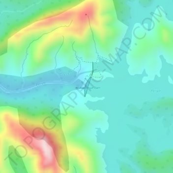
Nombre: Mapa topográfico Mullaperiyar Dam, altitud, relieve.
Lugar: Mullaperiyar Dam, Peerumade, Idukki, Kerala, India (9.52710 77.14375 9.53021 77.14486)
Altitud media: 922 m
Altitud mínima: 828 m
Altitud máxima: 1.147 m
Otros mapas topográficos
Haga clic en un mapa para ver su topografía, su altitud y su relieve.
Vagamon
Vagamon, due to its elevation and climate, has a unique ecosystem, leading to the emergence of rich natural vegetation, plant species, shola forests etc. From the early 20th century plantation crops like tea, coffee started. Vagamon hills are home to less explored flora and fauna. A faunal diversity study…
Altitud media: 866 m
Vandiperiyar
It is located at an altitude of 836 m above MSL.
Altitud media: 919 m
Elappara
Elappara is a town in Idukki district in the southwestern Indian state of Kerala. It is one of the panchayaths in Peerumedu taluk. The area is marked by a cool climate as the region is situated at an elevation of over 1,000 m (3,300 ft) above sea level. Elappara is famous for its vast tea plantations.
Altitud media: 1.049 m