
Haz una donación
Mapa topográfico Silverthrone Mountain
Haga clic en el mapa para ver la altitud.
Haz una donación
Silverthrone Mountain
Mount Silverthrone is perhaps one of the most heavily is perhaps one of the most heavily glaciated volcanic peaks in southwestern British Columbia. It has a topographic prominence of approximately 975 m (3,200 ft), greater than any other volcano in southwestern British Columbia. The extensive icefields around Mount Silverthrone are receding and are small compared to their former extent, but they are an impressive indication of how much of British Columbia looked 10,000 years or more ago. Silverthrone contains one of the few calderas buried beneath the ice caps of western Canada, another example being Mount Edziza in far northwestern British Columbia.
Haz una donación
Acerca de este mapa
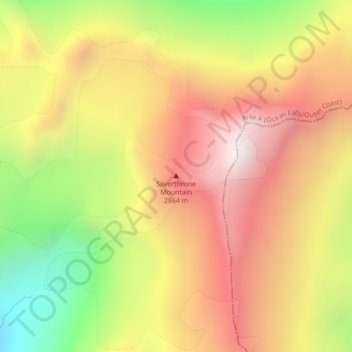
Nombre: Mapa topográfico Silverthrone Mountain, altitud, relieve.
Altitud media: 2.297 m
Altitud mínima: 1.809 m
Altitud máxima: 2.835 m
Haz una donación
Otros mapas topográficos
Haga clic en un mapa para ver su topografía, su altitud y su relieve.
Mayor Island
Canada > British Columbia > Regional District of Mount Waddington > Area A (Seymour Inlet/Knight Inlet)
Altitud media: 5 m
Kingcome Inlet
Canada > British Columbia > Regional District of Mount Waddington > Area A (Seymour Inlet/Knight Inlet)
Altitud media: 305 m
Mistake Island
Canada > British Columbia > Regional District of Mount Waddington > Area A (Seymour Inlet/Knight Inlet)
Altitud media: 24 m
Malcolm Island
Canada > British Columbia > Regional District of Mount Waddington > Area A (Seymour Inlet/Knight Inlet)
Altitud media: 21 m
Haz una donación