
Gracias por apoyar a este sitio ❤️
Haz una donación
Haz una donación
Mapa topográfico Gütersloh
Haga clic en el mapa para ver la altitud.
Gracias por apoyar a este sitio ❤️
Haz una donación
Haz una donación
Gütersloh
Gütersloh lies in the Emssandebene, south-west of the Teutoburg Forest and on the north-eastern edge of the Westphalian Basin and has no significant points of elevation. The city's lowest point is 64 metres (210 ft) above sea level on the river Ems near the Princess Royal Barracks and the highest point is 105 metres (344 ft) above sea level in the eastern township of Friedrichsdorf.
Gracias por apoyar a este sitio ❤️
Haz una donación
Haz una donación
Acerca de este mapa
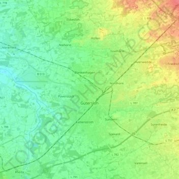
Nombre: Mapa topográfico Gütersloh, altitud, relieve.
Lugar: Gütersloh, Kreis Gütersloh, North Rhine-Westphalia, Germany (51.85597 8.28400 51.97709 8.50599)
Altitud media: 80 m
Altitud mínima: 61 m
Altitud máxima: 119 m
Gracias por apoyar a este sitio ❤️
Haz una donación
Haz una donación