
Haz una donación
Mapa topográfico Duff
Haga clic en el mapa para ver la altitud.
Haz una donación
Acerca de este mapa
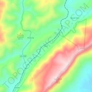
Nombre: Mapa topográfico Duff, altitud, relieve.
Altitud media: 527 m
Altitud mínima: 352 m
Altitud máxima: 781 m
Haz una donación
Otros mapas topográficos
Haga clic en un mapa para ver su topografía, su altitud y su relieve.
La Follette
United States > Tennessee > Campbell County
According to the United States Census Bureau, the city has a total area of 4.9 sq mi (12.7 km2), all land. The elevation varies around the city, around 1,050 ft (320 m) in the valley areas to 1,500 ft (460 m) on ridge tops. The average elevation is around 1,150 ft (350 m).
Altitud media: 396 m
Haz una donación