
Haz una donación
Mapa topográfico Tancheng
Haga clic en el mapa para ver la altitud.
Haz una donación
Acerca de este mapa
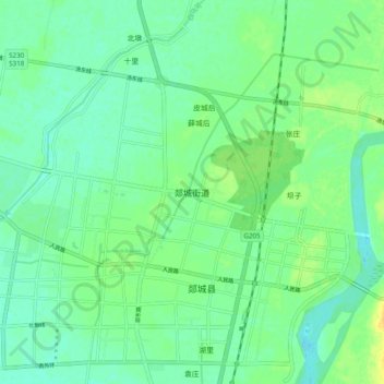
Nombre: Mapa topográfico Tancheng, altitud, relieve.
Lugar: Tancheng, Shandong, 276100, China (34.59173 118.31867 34.67173 118.39867)
Altitud media: 41 m
Altitud mínima: 32 m
Altitud máxima: 56 m
Haz una donación
Otros mapas topográficos
Haga clic en un mapa para ver su topografía, su altitud y su relieve.
Huancui District
Huancui District is relatively low in elevation, with only a few peaks rising above 500 metres (1,600 ft) in height. The district's southern edge lies along the eastern portion of the Jiaolai Plains [zh].
Altitud media: 41 m
Haz una donación
Qingdao City
Qingdao is located on the south facing coast of the Shandong Peninsula (German: Schantung Halbinsel). It borders three prefecture-level cities, namely Yantai to the northeast, Weifang to the west, and Rizhao to the southwest. The city occupies an area totaling 10,654 km2 (4,114 sq mi), and stretches in…
Altitud media: 37 m
Haz una donación