
Gracias por apoyar a este sitio ❤️
Haz una donación
Haz una donación
Mapa topográfico Tanjay
Haga clic en el mapa para ver la altitud.
Gracias por apoyar a este sitio ❤️
Haz una donación
Haz una donación
Acerca de este mapa
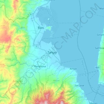
Nombre: Mapa topográfico Tanjay, altitud, relieve.
Lugar: Tanjay, Negros Oriental, Central Visayas, 6204, Philippines (9.35645 122.99664 9.67645 123.31664)
Altitud media: 172 m
Altitud mínima: -1 m
Altitud máxima: 1.233 m
Gracias por apoyar a este sitio ❤️
Haz una donación
Haz una donación
Otros mapas topográficos
Haga clic en un mapa para ver su topografía, su altitud y su relieve.
Dumaguete
As a coastal city, it is bounded on the east by the Bohol Sea and the Tañon Strait, serving as a natural border of southeastern Negros Island Region to the neighboring Central Visayas. The city's topography is generally flat from two to six kilometers from the shoreline. It slopes gently upwards to the…
Altitud media: 55 m
Gracias por apoyar a este sitio ❤️
Haz una donación
Haz una donación