
Gracias por apoyar a este sitio ❤️
Haz una donación
Haz una donación
Mapa topográfico Magic Lake
Haga clic en el mapa para ver la altitud.
Gracias por apoyar a este sitio ❤️
Haz una donación
Haz una donación
Acerca de este mapa
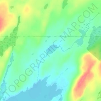
Nombre: Mapa topográfico Magic Lake, altitud, relieve.
Altitud media: 564 m
Altitud mínima: 540 m
Altitud máxima: 608 m
Gracias por apoyar a este sitio ❤️
Haz una donación
Haz una donación
Otros mapas topográficos
Haga clic en un mapa para ver su topografía, su altitud y su relieve.
Grand Portage National Monument
United States > Minnesota > Cook County
The portage begins on Lake Superior, elevation 600 feet (180 m), rising as it moves westward through two notches in the Sawtooth Mountain range. It briefly levels off around 1,000 feet (300 m) after 2.6 miles (4.2 km). Another 1.5 miles (2.4 km) you reach the inland county highway. From here, the trail is more…
Altitud media: 314 m
Gracias por apoyar a este sitio ❤️
Haz una donación
Haz una donación