
Mapa topográfico Isla Cozumel
Mapa interactivo
Haga clic en el mapa para ver la altitud.
Acerca de este mapa
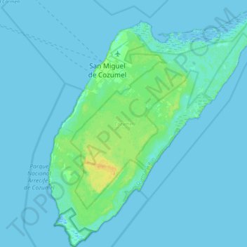
Nombre: Mapa topográfico Isla Cozumel, altitud, relieve.
Lugar: Isla Cozumel, Cozumel, Quintana Roo, Mexico (20.27200 -87.02520 20.59200 -86.72328)
Altitud media: 2 m
Altitud mínima: -3 m
Altitud máxima: 18 m
Large parts of the island are covered with mangrove forest which has many endemic animal species. Cozumel is a flat island based on limestone, resulting in a karst topography. The highest natural point on the island is less than 15 m (49 ft) above sea level. The cenotes are water-filled sinkholes formed by water percolating through the soft limestone soil for thousands of years. Eighteen deep cenotes and more than 250 shallow bodies exist on the island. Many are under dense vegetation. Jade Cavern Cozumel (Cenote Chempita) near El Cedral is often visited by tourists.
Otros mapas topográficos
Haga clic en un mapa para ver su topografía, su altitud y su relieve.
Playa Palancar
Mexico > Quintana Roo > Cozumel > Palancar
Playa Palancar, Palancar, Cozumel, Quintana Roo, Mexico
Altitud media: 1 m