
Mapa topográfico Swalcliffe
Haga clic en el mapa para ver la altitud.
Acerca de este mapa
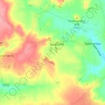
Nombre: Mapa topográfico Swalcliffe, altitud, relieve.
Altitud media: 163 m
Altitud mínima: 117 m
Altitud máxima: 213 m
Otros mapas topográficos
Haga clic en un mapa para ver su topografía, su altitud y su relieve.
Roman Meadow Banbury Country Park
United Kingdom > England > Oxfordshire > Cherwell District > Little Bourton
Altitud media: 103 m
Williamscot
United Kingdom > England > Oxfordshire > Cherwell District > Cropredy > Williamscot
Altitud media: 118 m
Stoke Lyne
United Kingdom > England > Oxfordshire > Cherwell District > Stoke Lyne
Altitud media: 116 m
Hampton Gay
United Kingdom > England > Oxfordshire > Cherwell District > Shipton-on-Cherwell
Altitud media: 75 m
Little Chesterton
United Kingdom > England > Oxfordshire > Cherwell District > Wendlebury
Altitud media: 72 m
Down End
United Kingdom > England > Oxfordshire > Cherwell District > Hook Norton
Altitud media: 173 m