
Haz una donación
Mapa topográfico Saint Catherine
Haga clic en el mapa para ver la altitud.
Haz una donación
Saint Catherine
Köppen-Geiger climate classification system classifies the climate as desert (BWh). Saint Catherine has the coldest nights of any city in Egypt, and its humidity is very low. The highest mountain ranges in Egypt surround the town, with many smaller valleys leading from the basin to the mountains in all directions. The township is at an elevation of 1,600 metres (5,200 ft). The high altitude of the town and the high mountain ranges which surround it provide a pleasant climate with mild summer nights and relatively cool winter days. The nights can get very cold on rare occasions, making it sometimes necessary to heat buildings and public places. Saint Catherine is considered to be one of the coldest towns in Egypt along with Nekhel and other locales in mountainous Sinai. Saint Catherine receives infrequent snowfalls during December, January, and February, however, snow has also occurred in late autumn and early spring.
Haz una donación
Acerca de este mapa
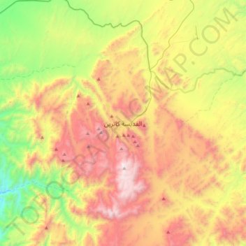
Nombre: Mapa topográfico Saint Catherine, altitud, relieve.
Lugar: Saint Catherine, South Sinai, Egypt (28.40751 33.79356 28.72751 34.11356)
Altitud media: 1.472 m
Altitud mínima: 520 m
Altitud máxima: 2.629 m
Haz una donación
Otros mapas topográficos
Haga clic en un mapa para ver su topografía, su altitud y su relieve.