
Haz una donación
Mapa topográfico Komsomolets Island
Haga clic en el mapa para ver la altitud.
Haz una donación
Acerca de este mapa
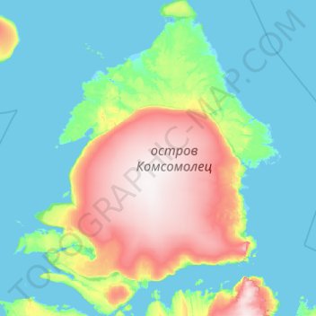
Nombre: Mapa topográfico Komsomolets Island, altitud, relieve.
Altitud media: 122 m
Altitud mínima: -3 m
Altitud máxima: 778 m
Haz una donación
Otros mapas topográficos
Haga clic en un mapa para ver su topografía, su altitud y su relieve.
Siberia
Russia > Krasnoyarsk Krai > Boguchansky Rayon
Eastern and central Sakha comprises numerous north–south mountain ranges of various ages. These mountains extend up to almost 3,000 metres (9,800 ft), but above a few hundred metres they are almost completely devoid of vegetation. The Verkhoyansk Range was extensively glaciated in the Pleistocene, but the…
Altitud media: 346 m
Tunguska event
Russia > Krasnoyarsk Krai > Evenkiysky Rayon
The Tunguska event was a large explosion of between 3 and 50 megatons that occurred near the Podkamennaya Tunguska River in Yeniseysk Governorate (now Krasnoyarsk Krai), Russia, on the morning of 30 June 1908. The explosion over the sparsely populated East Siberian taiga felled a large number of trees, over an…
Altitud media: 333 m
Byrranga Mountains
Russia > Krasnoyarsk Krai > Taymyrsky Dolgano-Nenetsky District
Altitud media: 904 m
Haz una donación
Haz una donación
Haz una donación
Haz una donación
Haz una donación
Haz una donación
Haz una donación
Haz una donación
Haz una donación