
Mapa topográfico Thringstone
Haga clic en el mapa para ver la altitud.
Acerca de este mapa
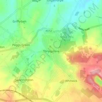
Nombre: Mapa topográfico Thringstone, altitud, relieve.
Altitud media: 126 m
Altitud mínima: 72 m
Altitud máxima: 205 m
Otros mapas topográficos
Haga clic en un mapa para ver su topografía, su altitud y su relieve.
Kelham Bridge Nature Reserve
United Kingdom > England > Leicestershire > North West Leicestershire > Ravenstone
Altitud media: 139 m
Castle Donington
United Kingdom > England > Leicestershire > North West Leicestershire > Hemington
Altitud media: 56 m
Swannington
United Kingdom > England > Leicestershire > North West Leicestershire > Coalville
Altitud media: 132 m
Ashby-de-la-Zouch
United Kingdom > England > Leicestershire > North West Leicestershire
Altitud media: 132 m
Lount Wood
United Kingdom > England > Leicestershire > North West Leicestershire > Lount
Altitud media: 131 m
Appleby Magna
United Kingdom > England > Leicestershire > North West Leicestershire
Altitud media: 95 m
Nailstone Colliery Railway
United Kingdom > England > Leicestershire > North West Leicestershire > Ibstock
Altitud media: 155 m
Sence Valley Country Park
United Kingdom > England > Leicestershire > North West Leicestershire > Heather
Altitud media: 131 m
Staunton Harold
United Kingdom > England > Leicestershire > North West Leicestershire > Lount
Altitud media: 108 m
Breedon Cloud Wood
United Kingdom > England > Leicestershire > North West Leicestershire > Breedon on the Hill
Altitud media: 90 m
Swannymote Rock
United Kingdom > England > Leicestershire > North West Leicestershire > Coalville
Altitud media: 139 m
Willesley Woods
United Kingdom > England > Leicestershire > North West Leicestershire > Ashby-de-la-Zouch > Willesley
Altitud media: 108 m
Normanton Le Heath
United Kingdom > England > Leicestershire > North West Leicestershire
Altitud media: 123 m
Kegworth
United Kingdom > England > Leicestershire > North West Leicestershire > Kegworth
Altitud media: 49 m
Ashby de la Zouch Canal
United Kingdom > England > Leicestershire > North West Leicestershire > Moira
Altitud media: 100 m
Worthington
United Kingdom > England > Leicestershire > North West Leicestershire
Altitud media: 103 m
Isley cum Langley
United Kingdom > England > Leicestershire > North West Leicestershire > Isley Walton
Altitud media: 80 m
Ashby de la Zouch Canal
United Kingdom > England > Leicestershire > North West Leicestershire > Oakthorpe
Altitud media: 97 m
Cademan Wood
United Kingdom > England > Leicestershire > North West Leicestershire > Whitwick
Altitud media: 138 m
New Lount Nature Reserve
United Kingdom > England > Leicestershire > North West Leicestershire > Worthington
Altitud media: 120 m