
Gracias por apoyar a este sitio ❤️
Haz una donación
Haz una donación
Mapa topográfico Bald Head
Haga clic en el mapa para ver la altitud.
Gracias por apoyar a este sitio ❤️
Haz una donación
Haz una donación
Acerca de este mapa
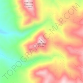
Nombre: Mapa topográfico Bald Head, altitud, relieve.
Lugar: Bald Head, Cache County, Utah, United States (41.47628 -111.76110 41.47638 -111.76100)
Altitud media: 1.944 m
Altitud mínima: 1.729 m
Altitud máxima: 2.124 m
Gracias por apoyar a este sitio ❤️
Haz una donación
Haz una donación
Otros mapas topográficos
Haga clic en un mapa para ver su topografía, su altitud y su relieve.
Clarkston
United States > Utah > Cache County
The townsite of Clarkston was laid out in 1864. It was named for Israel Justus Clark, who was an early settler and the first branch president of the Church of Jesus Christ of Latter-day Saints in Clarkston. The settlers originally settled east of modern-day Clarkston in a spot known as the flat. Due to water…
Altitud media: 1.498 m
Gracias por apoyar a este sitio ❤️
Haz una donación
Haz una donación
Gracias por apoyar a este sitio ❤️
Haz una donación
Haz una donación