
Gracias por apoyar a este sitio ❤️
Haz una donación
Haz una donación
Mapa topográfico Woolardtown
Haga clic en el mapa para ver la altitud.
Gracias por apoyar a este sitio ❤️
Haz una donación
Haz una donación
Acerca de este mapa
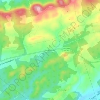
Nombre: Mapa topográfico Woolardtown, altitud, relieve.
Altitud media: 365 m
Altitud mínima: 294 m
Altitud máxima: 467 m
Gracias por apoyar a este sitio ❤️
Haz una donación
Haz una donación
Otros mapas topográficos
Haga clic en un mapa para ver su topografía, su altitud y su relieve.
Gracias por apoyar a este sitio ❤️
Haz una donación
Haz una donación
Cherokee Dam
United States > Tennessee > Jefferson County
Cherokee Dam is a gravity-type concrete spillway dam consisting of nine crest gates and eight sluice gates (the latter allowing reservoir control when water level is low). The combined capacity of the dam's four hydroelectric generators is 135,200 kilowatts. Cherokee Lake has a flood-storage capacity of…
Altitud media: 317 m
Gracias por apoyar a este sitio ❤️
Haz una donación
Haz una donación
Gracias por apoyar a este sitio ❤️
Haz una donación
Haz una donación