
Haz una donación
Mapa topográfico Angwin
Haga clic en el mapa para ver la altitud.
Haz una donación
Acerca de este mapa
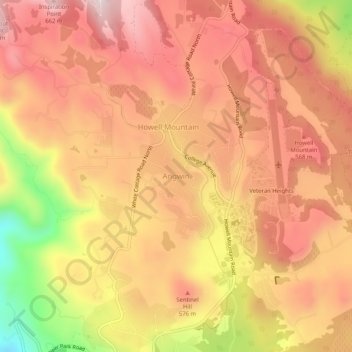
Nombre: Mapa topográfico Angwin, altitud, relieve.
Lugar: Angwin, Napa County, California, 94508, United States (38.55574 -122.46998 38.59574 -122.42998)
Altitud media: 517 m
Altitud mínima: 235 m
Altitud máxima: 669 m
Haz una donación
Otros mapas topográficos
Haga clic en un mapa para ver su topografía, su altitud y su relieve.
Napa Valley AVA
United States > California > Napa County
Napa Valley's climate and geography are shaped by a unique cooling effect, crucial for premium grape growing. Originating from a cold ocean current from Alaska, this effect involves fog formation and cool air influx from the Pacific, offset by warmer air rising from California's Central Valley. This dynamic…
Altitud media: 222 m
Haz una donación
Haz una donación
Napa Valley AVA
United States > California > Napa County
Napa Valley's climate and geography are shaped by a unique cooling effect, crucial for premium grape growing. Originating from a cold ocean current from Alaska, this effect involves fog formation and cool air influx from the Pacific, offset by warmer air rising from California's Central Valley. This dynamic…
Altitud media: 222 m
Haz una donación