
Haz una donación
Mapa topográfico Samaria
Haga clic en el mapa para ver la altitud.
Haz una donación
Acerca de este mapa
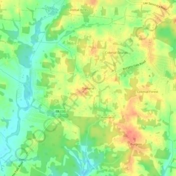
Nombre: Mapa topográfico Samaria, altitud, relieve.
Altitud media: 312 m
Altitud mínima: 286 m
Altitud máxima: 338 m
Haz una donación
Otros mapas topográficos
Haga clic en un mapa para ver su topografía, su altitud y su relieve.
Cookeville
United States > Tennessee > Putnam County
Located on the Highland Rim, Cookeville's elevation (1100 ft AMSL) is a few hundred feet higher than either Nashville or Knoxville. As a result, temperatures and humidity levels are generally slightly lower in Cookeville than in either the Nashville Basin or in the Tennessee Valley.
Altitud media: 332 m
Haz una donación
Cookeville
United States > Tennessee > Putnam County
Located on the Highland Rim, Cookeville's elevation (1100 ft AMSL) is a few hundred feet higher than Nashville's or Knoxville's. As a result, temperatures and humidity levels are generally slightly lower in Cookeville than in either the Nashville Basin or the Tennessee Valley.
Altitud media: 332 m
Chelsea Place Duck Pond
United States > Tennessee > Putnam County > Cookeville > Bilbrey Park
Altitud media: 341 m
Haz una donación