
Haz una donación
Mapa topográfico Beaverton
Haga clic en el mapa para ver la altitud.
Haz una donación
Acerca de este mapa
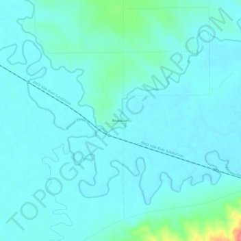
Nombre: Mapa topográfico Beaverton, altitud, relieve.
Lugar: Beaverton, Valley County, Montana, United States (48.40599 -107.27838 48.44599 -107.23838)
Altitud media: 669 m
Altitud mínima: 657 m
Altitud máxima: 743 m
Haz una donación
Otros mapas topográficos
Haga clic en un mapa para ver su topografía, su altitud y su relieve.
Glasgow
United States > Montana > Valley County
According to the United States Census Bureau, the city has a total area of 1.43 square miles (3.7 km2), all land. The town has an elevation of 2,093 feet (638 m). It is nestled in the Milk River Valley with the river itself meandering along to south.
Altitud media: 654 m
Haz una donación