
Mapa topográfico Roanoke
Mapa interactivo
Haga clic en el mapa para ver la altitud.
Acerca de este mapa
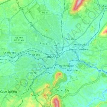
Nombre: Mapa topográfico Roanoke, altitud, relieve.
Lugar: Roanoke, Virginia, United States (37.21190 -80.03748 37.33761 -79.87855)
Altitud media: 333 m
Altitud mínima: 251 m
Altitud máxima: 680 m
Though located along the Blue Ridge Mountains at elevations exceeding 900 ft (270 m), Roanoke lies in the humid subtropical climate zone (Köppen Cfa), with four distinct, but generally mild, seasons, and it is located in USDA hardiness zone 7b, with the suburbs falling in zone 7a. Extremes in temperature have ranged from 105 °F (41 °C) as recently as August 21, 1983, down to −12 °F (−24 °C) on December 30, 1917, though neither 100 °F (38 °C) nor 0 °F (−18 °C) is reached in most years; the most recent occurrence of each is July 20, 2020 and February 20, 2015, respectively. More typically, the area records an average of 6.1 days where the temperature stays at or below freezing and 30.5 days with 90 °F (32 °C)+ highs annually. The normal monthly mean temperature ranges from 37.9 °F (3.3 °C) in January to 77.8 °F (25.4 °C) in July.
Otros mapas topográficos
Haga clic en un mapa para ver su topografía, su altitud y su relieve.
Burke
United States > Virginia > Fairfax County
Burke, Fairfax County, Virginia, 22015, United States
Altitud media: 97 m
Cascades
United States > Virginia > Loudoun County > Cascades
Cascades, Loudoun County, Virginia, 20165, United States
Altitud media: 81 m
Albemarle County
Albemarle County, Virginia, United States
Altitud media: 259 m
Simeon
United States > Virginia > Simeon
Simeon, Albemarle County, Virginia, 22909, United States
Altitud media: 166 m