
Mapa topográfico Cephalonia
Mapa interactivo
Haga clic en el mapa para ver la altitud.
Acerca de este mapa
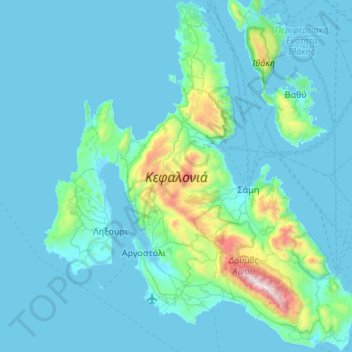
Nombre: Mapa topográfico Cephalonia, altitud, relieve.
Altitud media: 138 m
Altitud mínima: -2 m
Altitud máxima: 1.601 m
The island's highest mountain is Mount Ainos, with an elevation of 1628 meters; to the west-northwest are the Paliki mountains, where Lixouri is found, with other mountains including Geraneia (Gerania) and Agia Dynati. The top of Mount Ainos is covered with fir trees and is a natural park.
Otros mapas topográficos
Haga clic en un mapa para ver su topografía, su altitud y su relieve.
Antipata
Greece > Peloponnese, Western Greece and the Ionian > Kefallonia Regional Unit > Pylaros Municipal Unit > Antipata
Antipata, Pylaros Municipal Unit, Sami Municipality, Kefallonia Regional Unit, Ioanian Islands, Peloponnese, Western Greece and the Ionian, 28081, Greece
Altitud media: 387 m
Kefalonia
Greece > Peloponnese, Western Greece and the Ionian > Kefallonia Regional Unit
Kefalonia, Argostoli Municipality, Kefallonia Regional Unit, Ioanian Islands, Peloponnese, Western Greece and the Ionian, Greece
Altitud media: 60 m